Pyrenees – Mont Perdu
Summary
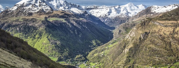
This spectacular mountain landscape, which extends across the French-Spanish border, is centred on the Mont-Perdu peak, a limestone massif which reaches a height of 3,352 metres. The site, with a total surface area of 30,639 hectares, includes two of the largest and deepest canyons in Europe on the Spanish side, and three large cirques on the steeper northern face in France, providing classic examples of these geological landforms. The site is also a pastoral landscape reflecting an agricultural way of life that was once widespread in the upland regions of Europe but now only survives in this part of the Pyrenees. It thus provides invaluable insight into past European society through its landscape of villages, farms, fields, upland pasture and mountain roads.
Criteria
Criteria (iii), (iv) and (v): The Pyrenees-Mont-Perdu site spanning France and Spain has an outstanding cultural landscape combining magnificent scenery and a socio-economic structure that has its roots in the past and illustrates an upland way of life that has become rare in Europe.
Criteria (vii) and (viii): The limestone massif of Mont Perdu has a number of classic geological formations such as deep canyons and spectacular cirques. It also has an outstanding landscape of meadows, lakes, caves, mountains and forests. It has significant scientific and conservation interest.
- Année d'inscription : 1997
- Critères d'inscription : iii, iv, v, vii, viii
- Superficie du bien inscrit : 30 639 ha
- Localisation : Department of Hautes-Pyrénées, Region Occitanie (France)
- Coordonnées DMS : N42 41 7.512 E0 0 1.8
- Registration year : 1997
- Registration criterion : iii, iv, v, vii, viii
- Area of the inscribed : 30 639 ha
- Location : Department of Hautes-Pyrénées, Region Occitanie (France)
- Coordinates DMS : N42 41 7.512 E0 0 1.8
Events

First meeting of Associations of World Heritage Properties in Europe
Strasbourg - Du 15 au 16 october 2015