Palace and park of Fontainebleau
Summary
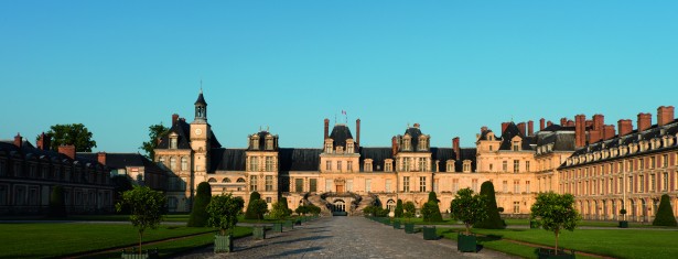
Set at the heart of a large forest in the Île-de-France, Fontainebleau had been a royal hunting lodge since the 12th century. It was transformed, enlarged and embellished in the 16th century by King François I who wanted to make it a “new Rome”. Renowned Italian artists, such as Serlio, Rosso, Le Primatice, and Nicolo dell’Abbate, were involved in the work, and the palace therefore combines Renaissance art and traditional French style. It was continuously maintained and embellished, and bears the mark of each resident sovereign up to Napoleon III. The current appearance of the domain is the result of these numerous transformations, and today it is composed of five irregularly arranged courtyards, flanked by buildings and gardens of different styles. The gardens, which are included in the 130 hectares of the listed site, were also extensively transformed over the centuries. They were eventually redesigned by Le Nôtre and gradually simplified; they are now composed of four parterres of lawn bordered by flowers.
The palace was the scene of significant historical events.
Criteria
Criterion (ii): The architecture and décor of the Palace of Fontainebleau exerted considerable influence on the development of art in France and Europe. The Italian painters, sculptors and architects appointed by the king had a decisive and permanent influence on French Renaissance art, giving it its most precious and prestigious models.
Criterion (vi): The Palace of Fontainebleau, which was a major royal residence for four centuries, is associated with events in French history of outstanding universal importance, notably the revocation of the edict of Nantes by Louis XIV in 1685, and the abdication of the Emperor Napoleon I in 1814.
- Année d'inscription : 1981
- Critères d'inscription : ii, vi
- Superficie du bien inscrit : 144 ha
- Localisation : Department of Seine-et-Marne, Region of Ile-de-France
- Coordonnées DMS : N48 24 7 E2 41 53
- Registration year : 1981
- Registration criterion : ii, vi
- Area of the inscribed : 144 ha
- Location : Department of Seine-et-Marne, Region of Ile-de-France
- Coordinates DMS : N48 24 7 E2 41 53
Same category
Events

First meeting of Associations of World Heritage Properties in Europe
Strasbourg - Du 15 au 16 october 2015